-
Home
-
About CHARIM
-
Countries
-
Methodology book
-
Use case book
-
Data management book
-
Forum
-
Geonode
You are here
9.6 Data sharing
Summary
To disseminate the geo-spatial data and value-added map products produced under this project, it was required to implement a Web GIS platform. Since GeoNode is a popular and powerful open source tool designed to cater such needs, it was chosen for implementing in the Caribbean region.
As a result of this project, GeoNodes have been developed in all five pilot countries in the Caribbean to facilitate this data sharing. As there were number of challenges identified in terms of infrastructure and technical limitations in the participating countries, a common GeoNode server has also been developed and hosted at a commercial service provider. All the five countries have access to this common server and they can use this system to share their geo-spatial data as an alternative. This common GeoNode server is not limited to share the data and maps produced during the project period. Users from each country can upload to this server and maintain any geo-spatial data of their respective countries. Importantly, though data is available in a common platform, the access permissions can be set by the owner of any given data set. In other word, if a country does not want to publicly share a dataset, it is possible to restrict that dataset from viewing and downloading.
Keywords:
GeoNode, Data Sharing
Use case intended for:
Spatial analist
| Before you start: | Use case Location: | Uses GIS data: | Authors: |
|
An open source spatial data sharing web platform called GeoNode is considered throughout this section. To learn more about GeoNode, the readers are encouraged to visit http://geonode.org/ |
Belize, Dominica, Grenada, St. Lucia, and St. Vincent and the Grenadines |
Yes |
Dr. Manzul Kumar Hazarika and Ramesh De Silva |
Introduction:
This Use Case focuses to provide a means to share geo-spatial data in a web platform. Hundreds of new data sets are being produced for each country during this project. Apart from that, each country has many useful geo-spatial data which can be utilized for disaster risk reduction activities. The effectiveness of this data largely depends on how quickly and how many people can get access to the data. To fulfill these needs, a geo-spatial data sharing framework named GeoNode is being used. Such geo-spatial data-sharing framework allows thousands of people to access geospatial data over the internet without using any GIS software. Both vector and raster data can be uploaded to the GeoNode by authorized users. A centralized administration is very much desirable in GeoNode in order to provide a controlled access to the data and to maintain the consistency and authenticity of the available datasets. The system administrator of the GeoNode may create users of the system and assign permission according to their role. It is important to take steps to avoid duplicate data uploads and to insert relevant meta-data while uploading any dataset.
Under The Caribbean Risk Information Program, GeoNode have been established at five countries in Caribbean namely Belize, Dominica, Grenada, St. Lucia and St. Vincent. It is important to do a detail analysis of the current status of GeoNode established at each country in order to find the gaps and provide necessary support to fill those gaps and maximize the usage of the GeoNodes.
Objectives:
- To provide a means to share geo-spatial data;
- Establish GeoNode as the geo-spatial sharing platform in all five countries;
- Encourage data sharing in the five countries.
Flowchart:

Figure 1: Flowchart of data sharing process
Problems definition and specifications:
In order to obtain the maximum benefits from an online data sharing platform, it is required to have a well-planned, organized and carefully coordinated framework behind the scene. Unless the framework is designed and implemented carefully, considering all required aspects in a country, the outcome may not be useful. For an example, if the accuracy of the uploaded data is poor, then obviously the decisions taken on the basis of such data may lead to problems. Similarly, unless there is a proper understanding and harmony among the stakeholders in place, it will be difficult to have the updated and accurate datasets. Some of the important factors for data sharing are as follows:
1. Leadership
Leadership is the key factor in this framework. Simply speaking, someone needs to take the lead role in this task. For an example, in Belize, The Ministry of Natural Resources and Agriculture has taken the initiative to establish the NSDI under their ministry. Since all the stakeholders are supposed to use a single GeoNode to share their respective data, it is required to have centralized administration for the system. Hence, the best practice would be that the NSDI appoint an Administrator for the GeoNode system and facilitate controlled access to the system. It is the responsibility of the NSDI to define required policies and procedures collectively with all stakeholders in order to guarantee the smooth and continues usage.
2. Identifying stakeholders / reluctance to share data by the stakeholders
In most of the cases, data is available with different agencies/departments. Hence there is no need to reproduce them, but the challenge is to locate them and make them sharable. By bringing various stakeholders under one umbrella, it becomes easier to obtain data from different agencies/departments for sharing. NSDI should be the focal point in this task. NSDI needs to encourage and setup institutional agreements on data sharing policies. It is the responsibility of NSDI to define the responsible departments for primary data, based on their domain.
To make the data sharing successful, it is important to receive due support from the governments of the respective countries. This would help in developing a proper coordination mechanism among the agencies. Hence, the ministry or the agency establishing the NSDI should make sure to receive government’s support and receive cooperation form different agencies/departments.
3. Lack of infrastructure
It is also important to plan about the necessary IT infrastructure for the data sharing platform as it will demand significant amount of resources to store huge amount of data, and concurrent connections to various servers. Further, a reliable network with sufficient bandwidth will be required. To make the system operational for 24x7, it is required to plan for redundant power supplies, system backups etc. If it is difficult to find adequate infrastructure support within a country, it is possible to host this system somewhere else.
Data requirements:
-
GIS and remote sensing data with metadata
Results:
In order to facilitate data sharing, GeoNodes have been established in all five countries as well as a common GeoNode has been implemented in a cloud server. All the data and maps produced during the project are being uploaded to this common GeoNode. All five countries have access to the common GeoNode and they can upload geo-spatial data to the same.
The following figure shows the common GeoNode established under this project. This GeoNode (CHARIM GeoNode) can be accessed at http://www.charim-geonode.net/ .
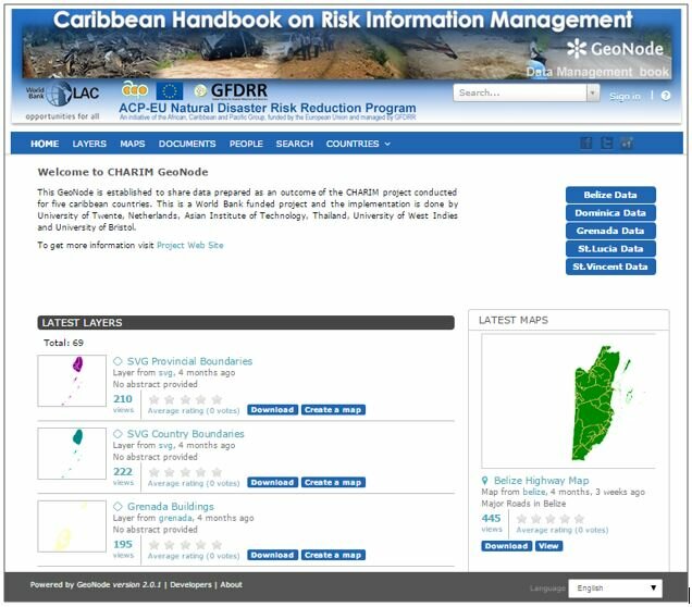
Figure 2: CHARIM GeoNode
On the home page of the common GeoNode, data representing all five countries can be accessed. But, if someone needs to visualize data belonging to a particular country, then it is possible to filter and visualize data of that country only as shown below.

Figure 3: Country Specific Data
Each country is given a username and a password to access the GeoNode.

Figure 4: Users of the GeoNode
The following figure shows the GeoNode data-sharing platform established for Dominica.

Figure 5: Dominica GeoNode
The following figure shows the GeoNode data-sharing platform established for St. Lucia.

Figure 6: Saint Lucia GeoNode
The following figure shows the GeoNode data sharing platform established for Belize.

Figure 7: Belize GeoNode
- Data visualization
It is possible to visualize available datasets in the GeoNode. As shown in the following figure, it is possible to categorized datasets by grouping them based on a certain field in the attribute tables. GeoNode provides options to visualize legends, zoom in, zoom out, measure distance, query information, overlay on Google Earth etc. while previewing datasets.

Figure 8: Thematic Maps
Conclusions:
GeoNode is a simple but powerful platform to share and publish geospatial data. GeoNode has been established at five pilot countries in the Caribbean region namely, Belize, Dominica, Grenada, St. Lucia and St. Vincent, but factors such as infrastructures, resources, capacities and coordination among the stakeholders will ultimately determine their sustainability. If the pilot countries can meet these challenges, then the GeoNode can facilitate a robust geospatial data sharing platform for implementing multi-disciplinary projects such as multi-hazard risk assessment and management, which will help them to make informed decision making. A common GeoNode has also been implemented remotely to share geo-spatial data until the pilot countries reach to a level where they can maintain their own GeoNodes.
Last update:
07-06 - 2016
Post new comment